
Every asset manager knows the uncomfortable truth about the register. It was accurate on the day the survey finished. It has been drifting ever since. Signs fade, potholes open, line markings wear away. The spreadsheet that anchors the asset management plan quietly stops describing the network it is meant to represent. This is the road condition assessment problem in one line: the survey ends, and the data starts ageing immediately. Then a resident complaint, an insurance claim, or an audit question lands. Suddenly the team is defending decisions with data from two budget cycles ago.
It does not have to work that way. Transport for NSW ran an AI road condition assessment across a 200 kilometre network and surfaced more than 54,800 road defects in a single mobilisation. Each defect arrived classified, severity rated, and pinned to a GPS coordinate. Wollongong City Council captured 170 kilometres across four suburbs and received the data in its exact GIS specification. The capability behind both programmes is SenMAP, SenSen’s asset intelligence platform. This article explains how councils keep a living record of network condition from routine vehicle passes. It covers what changes for maintenance, renewal planning, and risk.
Why do council asset registers go out of date?
Asset registers go out of date because the traditional survey model captures the network as a one-off project, every few years, while the network itself changes daily. The register is a snapshot. The road is a moving picture.
The standard cycle looks like this. A council commissions a condition survey, and a specialist vehicle or inspection crew works through the network over several months. The results land in the asset system, and for a while the data is trustworthy. Then reality resumes. Storms move kerbs and crack pavements. Contractors dig and reinstate. Signs get clipped by trucks. By the time the next survey is funded and scheduled, teams are planning renewals against a register that no longer matches the street.
Manual inspection compounds the problem. Different inspectors make different judgment calls, so condition ratings are hard to compare year on year. And because a full-network survey is a significant procurement, most councils cannot afford to run one often enough to keep pace. The gap between surveys is where liability lives: the trip hazard nobody logged, the faded give-way sign nobody flagged.
That gap is what councils are now closing with AI capture. It is why asset condition sits alongside compliance, safety, and business intelligence in how councils structure their city data.
What is survey by doing?
Survey by doing means capturing asset and condition data from vehicles a council already has on the road, so the survey happens as a by-product of routine operations rather than as a separate project.
A patrol vehicle, a waste truck route, or a dedicated drive with a camera kit becomes the capture surface. AI processes the footage, detects every asset and defect in view, and updates the register automatically. Nobody fills in an inspection form. Nobody books a specialist survey vehicle. The operator drives the route they were going to drive anyway, and the data arrives as a finished dataset.
This flips the economics of network knowledge. When a survey is a project, councils ration it: main roads this cycle, everything else when budget allows. When capture rides on routine passes, re-surveying a corridor costs a drive. The register stops being a snapshot and becomes a time series, a record of how every street is trending, not just how it looked once.
SenMAP delivers this in two parts. SenMAP Digital Twin builds the GPS-accurate inventory: signs, poles, kerbs, hydrants, pay stations, line markings and more, detected, catalogued and condition scored. SenMAP Asset Conditioning watches for defects and change over time. Councils start with one and add the other; the city asset management overview covers both.
How does AI detect road defects from a council vehicle?
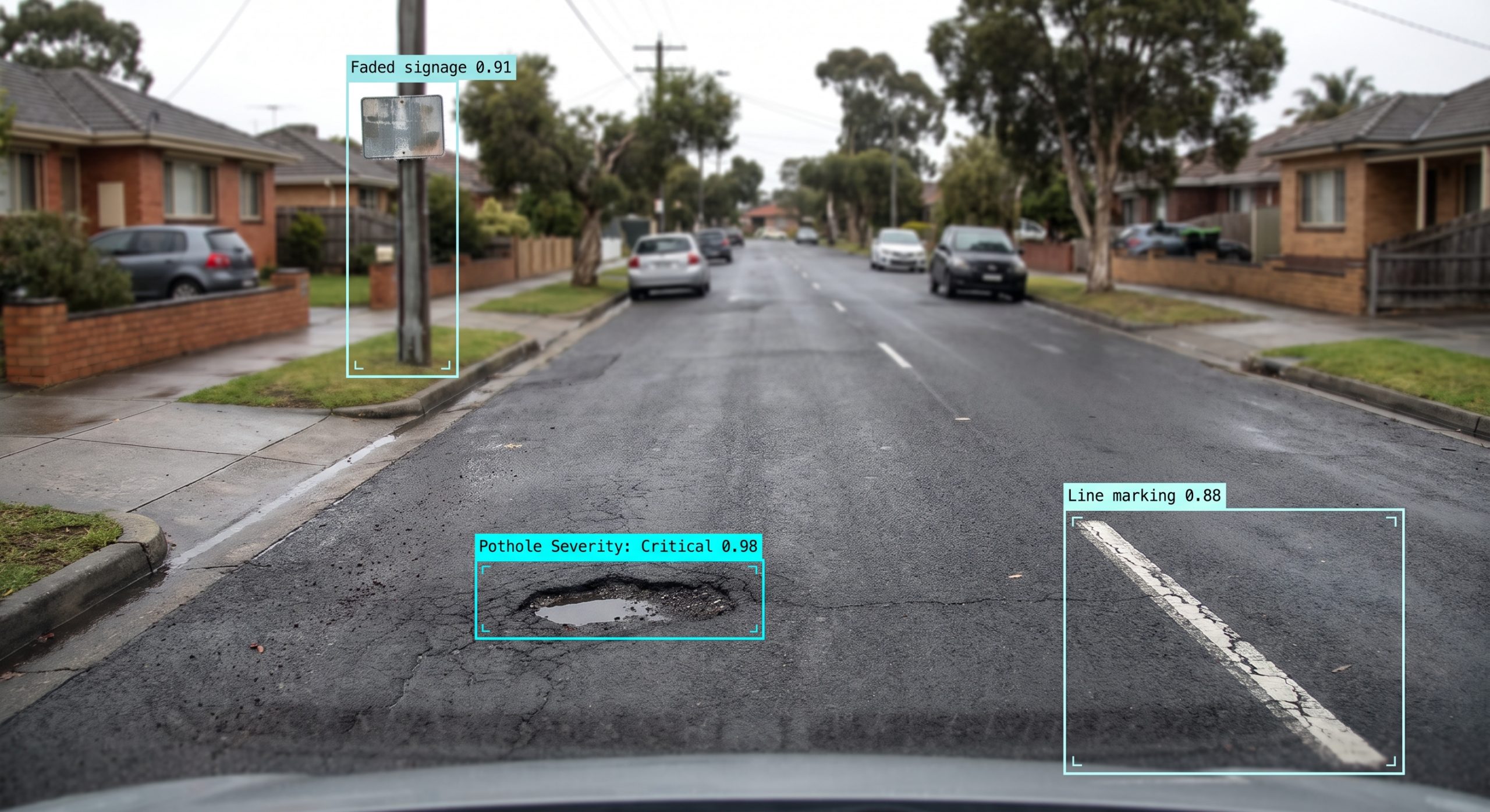
AI-based road condition assessment processes camera footage from the vehicle and detects more than 40 defect types across four families: pavement, signage, hazards, and compliance. Every detection arrives with a severity rating, a confidence score, and a GPS pin.
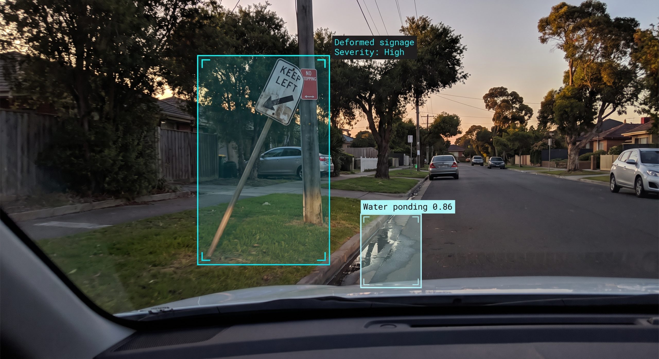
In practice that means the system picks up potholes, cracking and rutting in the pavement family. It catches faded, damaged, and low-visibility signage, including signs that no longer reflect properly at night. It flags hazards such as trip points, water ponding at the kerb line, overgrown vegetation, and broken safety barriers. And it surfaces compliance issues like illegal dumping, unauthorised advertising signage, and abandoned vehicles.
Severity is the operative word. A register that lists ten thousand defects is noise. A ranked register, potholes and trip hazards critical, worn line markings high, litter medium, is a maintenance programme waiting to be scheduled. Detections can flow straight into the council’s asset management system as work orders, so the path from detection to repair crew is short.
The detection library also grows. When a council needs a new category, a specific sign defect or a new pavement failure type, SenSen trains the model for it. The next drive picks it up. The system’s value compounds over time rather than being fixed at purchase.
What does a council do with a living asset register?
A living register turns three chronic arguments into short conversations: what to fix first, what to fund next, and how to prove the council acted reasonably.
Maintenance prioritisation comes first. With every defect severity rated and geolocated, the works programme is built on evidence rather than on whichever complaint arrived loudest. Teams can see clusters, watch a corridor deteriorate across successive passes, and intervene before failure. Acting early is almost always cheaper than reacting after it.
Renewal planning is next. Asset management plans and long-term financial plans are only as defensible as the condition data underneath them. A register refreshed by regular re-drives gives finance a current, consistent baseline, the same methodology every pass, comparable year on year. That is the difference between a renewal bid built on evidence and one built on extrapolation.
Then there is risk. Councils carry a duty to inspect and maintain their networks. When a claim arrives, the question is always the same: what did you know, and when? A time-stamped, GPS-accurate condition record answers it. The same evidence base supports road management plan compliance and gives insurers and auditors something better than an inspection diary.
There is a quieter benefit too. The same capture that finds defects also finds conflicting, damaged, or missing regulatory signage. That feeds back to the compliance team, so officers do not issue notices against faulty signage. Fewer bad tickets, fewer disputes, and a cleaner link between the asset base and fair, defensible enforcement.
How does this hold up after storms and floods?
After a disaster, a council with a pre-event condition baseline can evidence damage quickly and credibly. Rapid re-capture of the affected network produces before-and-after deltas, geolocated and time-stamped, in the form disaster recovery funding assessors expect.
In Australia this matters most for Disaster Recovery Funding Arrangements claims. The difference between a substantiated claim and an estimate can be material to the recovery budget. A council that last surveyed its network three years before the flood is negotiating from memory. A council with a recent baseline drives the damaged corridors, captures the change, and submits evidence.
The same logic applies anywhere. Insurance disputes, funding acquittals, and post-event audits all reward the council that can show network condition on a known date. Because re-drives are fast and repeatable, the baseline is never far out of date.
What have councils and agencies done with it?
The published Your Streets programme covers four deployments on one platform, each proving a different part of the capability.
Transport for NSW ran proactive detection across a 200 kilometre network and surfaced more than 54,800 defects in one mobilisation, delivered on specification. Wollongong City Council captured 170 kilometres across four suburbs, with every sign detected and the dataset delivered to the council’s exact GIS requirements. It is now expanding into road asset baselining. Brisbane City Council runs detection and enforcement on one stack, including advertising-compliance monitoring, work recognised with a national industry award. In North America, Toronto Parking Authority used the same approach across a 500 kilometre network, surfacing 5,500 assets and 21,500 parking spaces.
Four organisations, four starting points, one pattern. The vehicle pass does the surveying, the AI does the classifying, and the team receives a dataset it can act on. The full stories are in the Your Streets case study.
How does a council get started?
Councils start by choosing a capture method that fits the fleet they already run, then scoping a baseline: which suburbs, which asset types, which defect families.
Capture is flexible by design. An enforcement patrol vehicle already driving the network can collect asset data in parallel. A rapid-deploy camera kit, SenFORCE RDK, mounts on any council vehicle in minutes for targeted campaigns. Staff can capture spot checks through a smartphone app. SenSen’s team can run the city-wide baseline capture end to end. And existing CCTV or drone footage can be ingested where it already exists.
From there the workflow is short: plan the routes, drive them, let the AI process and classify, and receive the data. Delivery is through a dashboard, APIs, or GIS-ready exports in the formats council systems already accept. Nothing is captured until the council confirms the scope. Imagery is automatically de-identified, faces and number plates blurred, before data enters the platform.
The contrast with the traditional model is the point. Standard practice re-surveys the network on a multi-year cycle. A survey-by-doing programme refreshes it as often as the routes are driven. The first pass builds the baseline; every pass after that builds the trend line. See what a baseline would look like on your network at the city asset management page.
FAQ
What is road condition assessment?
Road condition assessment is the process of measuring the state of a road network, its pavement, signage, markings, and kerbside assets, so a council knows what needs maintaining and when. Traditional assessment runs as a periodic contractor survey. AI road condition assessment captures the same information continuously from routine vehicle passes, so the register stays current between formal surveys.
What is SenMAP?
SenMAP is SenSen’s asset intelligence platform for councils and road authorities. It captures road, footpath, and kerbside asset data from vehicle passes and detects more than 40 defect types with severity and confidence scoring. Datasets arrive GPS-accurate, in the formats existing GIS and asset management systems accept. It has two modules: SenMAP Digital Twin for asset mapping and SenMAP Asset Conditioning for defect detection.
Does automated defect detection replace council inspection teams?
No. The AI does the scanning; people make the decisions. Automated capture takes the repetitive surveying load off inspection teams so their time moves to judgment work: verifying critical defects, prioritising repairs, and managing programmes. Staff also correct the AI where it gets a detection wrong, and the system learns from every correction.
How often should a council re-survey its road network?
Standard council practice re-surveys on a multi-year cycle, commonly four years, which is the cadence asset management planning is built around. With drive-based AI capture, councils refresh high-change corridors monthly or quarterly and the wider network opportunistically. A re-survey costs a drive rather than a procurement.
SenSen works with councils, cities, and transport authorities across 25+ countries on compliance, roads, assets, safety, and business intelligence. Explore how councils use city asset management, or read the Your Streets case study.